
Location: Monte Vista, CO
Job Description:
The Great Basin Institute is an interdisciplinary field studies organization that promotes environmental research, education, and service through the west. The Institute’s mission is to advance applied science and ecological literacy through community engagement and agency partnerships, supporting national parks, forest, open spaces and public lands.
The Aquatic Monitoring Program at GBI serves as an excellent professional development opportunity for natural resource professionals seeking experience in aquatic, riparian, and rangeland surveys. This Program is a component of our well-established Research Associate Program, which focuses on the conservation and management of natural, cultural, and recreation resources in the Intermountain West while providing emerging professionals opportunities to begin or enhance their careers.
GBI’s Aquatic Monitoring Program is dedicated to providing college graduates and emerging professionals with hands-on survey, inventory, monitoring, and reporting experience in natural resource management. Extensive training and technical field skills development provides employees a unique opportunity to obtain valuable experience in executing monitoring protocols that will increase their employment success.
Description:
GBI is recruiting Aquatic Monitoring Field Technicians to assist in the implementation of the Bureau of Land Management’s (BLM) National Aquatic Monitoring Framework (NAMF) for Assessment, Inventory, Monitoring (AIM) of lotic ecosystems, as well as the Multiple Indicator Monitoring (MIM) of stream channels and streamside vegetation. The Aquatic Monitoring Field Technicians will work with BLM staff, GBI staff and Aquatic Monitoring Field Leads and Riparian Botanists. Each Field Technician will work as part of a two-person crew (one Crew Lead, one Technician) in Western Colorado or three-person crew (one Crew Lead, one Riparian Botanist, one Technician) in Eastern Oregon to sample streams and rivers and assess riparian vegetation on BLM-managed land using the BLM’s Aquatic AIM protocol. If part of a three-person crew, crews will also assess riparian vegetation using the MIM protocol for stream channels and streamside vegetation. AIM seeks to standardize the collection of quantitative data that can be used at multiple scales to assist the BLM in making resource management decisions.
More information about AIM and AIM implementation can be found at http://aim.landscapetoolbox.org/
More information about MIM can be found at: https://www.blm.gov/documents/national-office/blm-library/technical-refe...
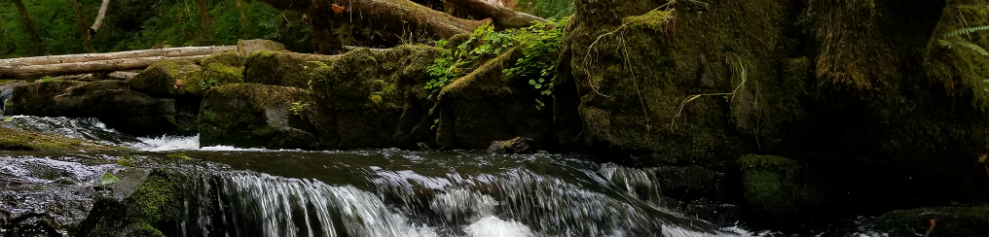
Aquatic monitoring crews will sample streams and rivers on BLM-managed lands in Western Colorado and Eastern Oregon using the BLM’s AIM protocol for wadeable lotic systems. Crews will interact with local BLM staff, national level staff at the National Operations Center (NOC), and GBI senior monitoring staff. Data collection involves measuring a variety of attributes including water chemistry and instream physical habitat, collecting aquatic macroinvertebrates, and conducting visual estimates in the riparian zone. Successful applicants will be required to work and camp in the field during 8-day sampling efforts (8 consecutive 10 hour days, followed by 6 days off). Applicants should be prepared to encounter strenuous working conditions, including off-trail hiking and traversing streams. Additional efforts might be required to reach difficult sites, including overnight backpacking and use of off road vehicles and UTVs.
Field work and duties may include:
• Route planning utilizing ArcMap, Google Earth, Avenza, and CalTopo;
• Navigating unmaintained roads and off-trail to sampling sites utilizing GPS and backcountry navigation techniques;
• Establishing sampling reaches and transects;
• Entering data into and managing the Survey 123 and FieldMaps Ipad applications (Aquatic Data Management Protocol and Lotic • Technology and Applications Protocol); and
• Identifying plants to species using dichotomous keys.
Additional duties include:
• Maintaining safety awareness and practices;
• Regular communication with GBI support staff and BLM staff; and
• Participation in GBI and BLM-led trainings.
Colorado Aquatic Sampling Map: (CO District and Field Office Map) Oregon Aquatic Sampling Map: (OR District Interactive Map)
Required Qualifications:
• Experience, education, or a combination of the two in natural resources and field data collection to meet one or both of the following:
• Bachelor’s Degree in Natural Resources, Ecology, Biology or related subject; OR
• Minimum of 2 years field data collection
• Coursework or equivalent experience in aquatic biology, hydrology, entomology, geomorphology, plant taxonomy and/or systematics;
• Experience conducting field work using various monitoring protocols;
• Experience with data entry and management;
• Strong interest in aquatic ecology and physical processes;
• Navigating off-trail to sampling sites;
• Ability to swim, sample in cold water, walk on uneven surfaces, and bushwack on steep terrain, sometimes hiking up to 10 miles a day.
• Willingness to spend 8 consecutive days camping in the field where multiple hazards may be encountered, while sometimes working irregular hours and camping in a new location each night
• Willingness to work multiple days in the field with limited or nonexistent phone or internet service.
• Ability to work in harsh and rapidly changing environments, carry 40-50lbs in a backpack, traverse over uneven terrain and otherwise maintain good physical condition.
Valid, state-issued driver’s license and clean driving record;
• Ability to complete a Department of Interior (DOI) Background Investigation (BI) and submit paperwork to BLM human resources prior to beginning position indicating that an active and fully adjudicated BI has been started or completed;
• Ability to work productively as part of a team as well as independently to accomplish mutual goals;
• Ability to communicate effectively with team members, agency staff, and a diverse public;
• Excellent organizational skills; and
• Familiarity with best practices for field safety and Leave No Trace principles.
Preferred Qualifications
• Experiences conducting aquatic monitoring, utilizing photo documentation and site observations;
• Familiarity with lotic systems of the western United States;
• Ability to read, interpret and navigate using topographic maps;
• Experience navigating and collecting coordinates with hand-held GPS units;
• Experience creating maps and performing basic functions with ESRI software (ArcMap, ArcGIS, ArcGISPro);
• Experience using Google Earth, CalTopo, Avenza;
• Experience using backcountry communication devices such as InReaches or Satellite Phones; and
• Backcountry travel experience and solid navigational skills.
Application review will continue until all positions are filled. We encourage applying early in order to gain the best chance at getting your top-choice locations. Only qualified candidates will be contacted.